Getech has reprocessed and integrated all pre-2014 non-confidential gravity and magnetic data of Petroleum Agency SA covering the offshore of South Africa. These re-invigorated datasets comprise high-resolution marine profile data covering the Orange, Outeniqua, Southern Natal Valley and southern Mozambique Basins. Getech is authorised to release deliverables derived from these datasets including grid and profile data.
Gravity and magnetic data have been acquired on the offshore South African margin since 1972, often in conjunction with seismic surveys. The current data comprise 34 non-confidential surveys held by Petroleum Agency SA totalling over 100,000 km of gravity and magnetic data (Fig. 1). It has been demonstrated that careful validating, editing, micro-levelling and linking of the data has resulted in an excellent self-consistent dataset to support exploration in the region.
In this blog we show an example of how our reprocessing of the dataset has helped us to clear up some South Atlantic plate-fit and structural geology questions.
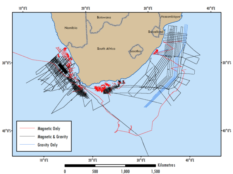
Figure 1. Location of the pre-2014 non-confidential reprocessed gravity and magnetic data offshore South Africa.
In the west coast OB122D-01 survey, located offshore Cape Town, the gravity data showed significant line noise (Fig. 2). Our reprocessing workflow has resulted in the removal of the line noise. Also, the newly-processed magnetic data now clearly shows magnetic anomalies/stripes, aiding our geological understanding and interpretation of the crustal architecture of the area.
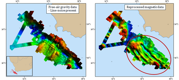
Figure 2. Free-air gravity prior to Getech reprocessing (left) and magnetic anomaly after Getech reprocessing (right).
The linear magnetic anomalies show a systematic offset indicative of a fracture zone (Cape/Hope Fracture Zone shown as the white stippled line in Fig. 3). To the south of the fracture zone the gridded magnetic data show the character of a magma-poor transitional margin, with continental break-up at chron M11 (136 Ma). To the north, chron M11 lies in a zone of broad high-amplitude magnetic anomalies corresponding with seaward-dipping reflector sequences, that suggest a magma-rich continental break up. To the north, the first magnetic anomaly lying on true oceanic crust is chron M7 (133 Ma). Understanding these variations in break-up timings, and the actual nature of the break-up in the different areas, has allowed us to refine and enhance our plate model solution in the southern South Atlantic, which forms part of Getech’s Global Plate Model.

Fig. 3. Integrated Petroleum Agency and Getech magnetic data.
Getech is licensed to release deliverables derived from the non-confidential offshore gravity and magnetic data made-up of high-resolution marine profile data, covering the Orange and Outeniqua Basins, and marine profile data, covering the Southern Natal and Southern Mozambique Basins. The data are integrated with Getech’s global Gravity and Magnetic data.
This combined data set (Fig. 4) has provided us with fresh insights into the basin structuration, evolution and prospectivity of the region, as was applied in the Getech regional report covering the stratigraphic framework and hydrocarbon prospectivity of the Southern African basins between the Walvis Ridge in the northwest and the Mozambique Basin in the northeast.
For further information regarding the fantastic self-consistent gravity and magnetic data sets and the comprehensive, data-rich regional report contact Getech.
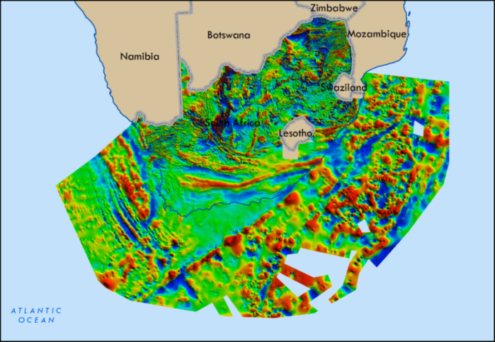
Figure 4: The reprocessed Petroleum Agency SA magnetic data integrated with the Getech offshore and onshore data.

