


Why Use High-Resolution Gravity Data?
High-resolution gravity data is an essential part of a balanced exploration campaign. It is an excellent tool with which to map structural lineaments, identify the location and extent of target structures, model sediment thickness, map lateral lithological changes and reduce uncertainties in seismic interpretation. Getech’s data for the Permian Basin shows a remarkable correlation with known hydrocarbon plays. As such, it is an extremely powerful tool for mapping the extensions of these plays and for directly identifying potential new opportunities.
Permian Basin Case Study
Getech’s high-resolution gravity database for the Permian Basin is derived from a compilation of numerous land gravity surveys. The data have been systematically validated, reprocessed to common parameters and merged to form the most comprehensive and coherent gravity database over the entire Permian Basin area. In this blog, we show examples of correlations with hydrocarbon plays from the New Mexico-Texas border area which illustrate the significant value of these data sets and carefully constructed derivatives.
The Leonard Restricted Platform Carbonate Play
The Leonard Restricted Platform Carbonate Play has a cumulative production rate that is well in excess of 3 billion bbl. In Figure 1, we show Getech’s high-resolution Bouguer anomaly gravity map. When we overlay the locations of known producing reservoirs of the Leonard Play (Figure 2), we observe a striking correlation along a NNW–SSE-trending series of gravity anomalies. Stretching from the vicinity of Pecos and Cane counties in the south to Lea and Gaines counties in the north, the producing plays are consistently clustered along the ridge or on the flanks of a prominent gravity high (the red colours in Figure 2).
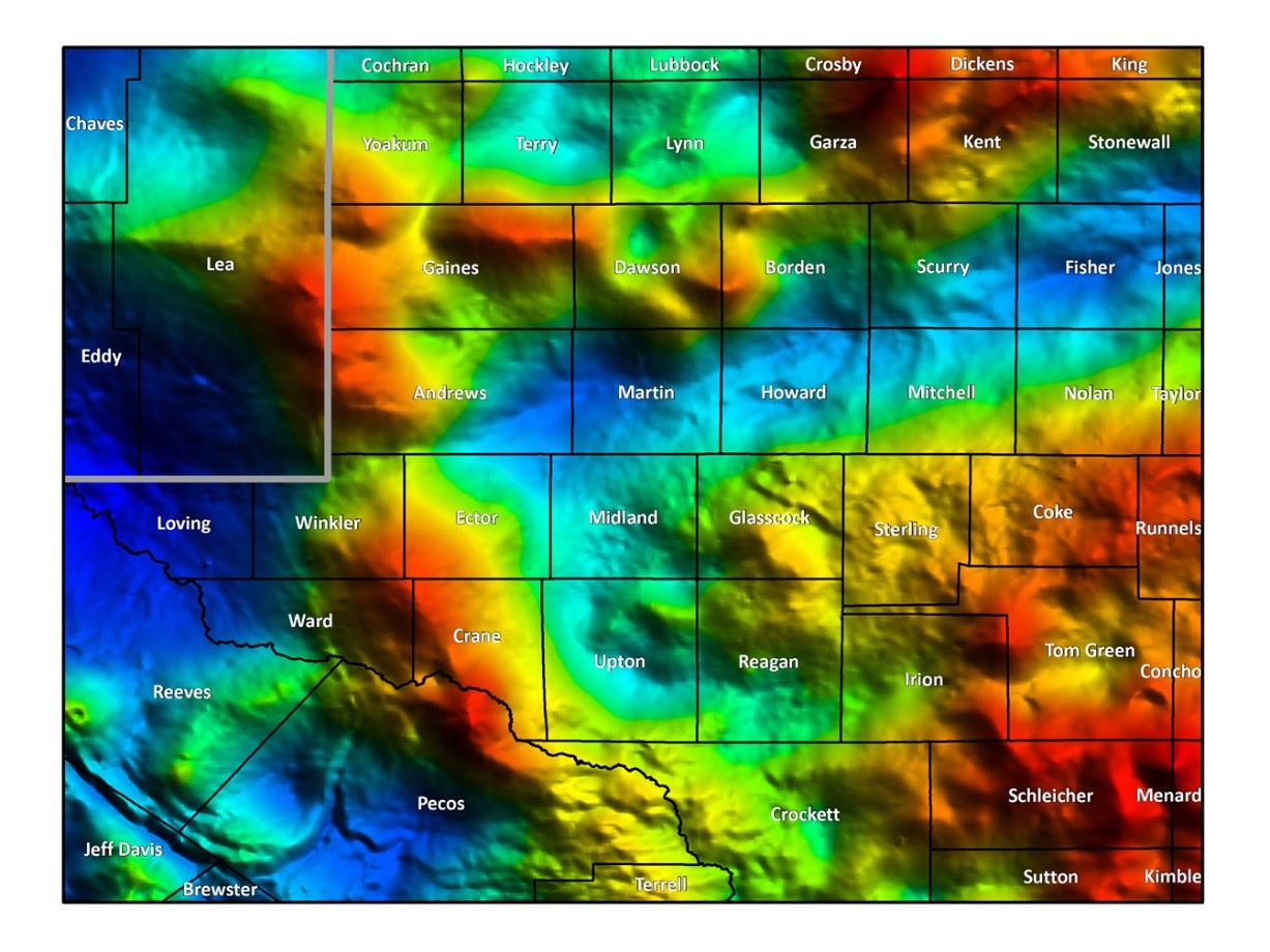
Figure 1. Bouguer gravity anomaly derived from numerous ground surveys.
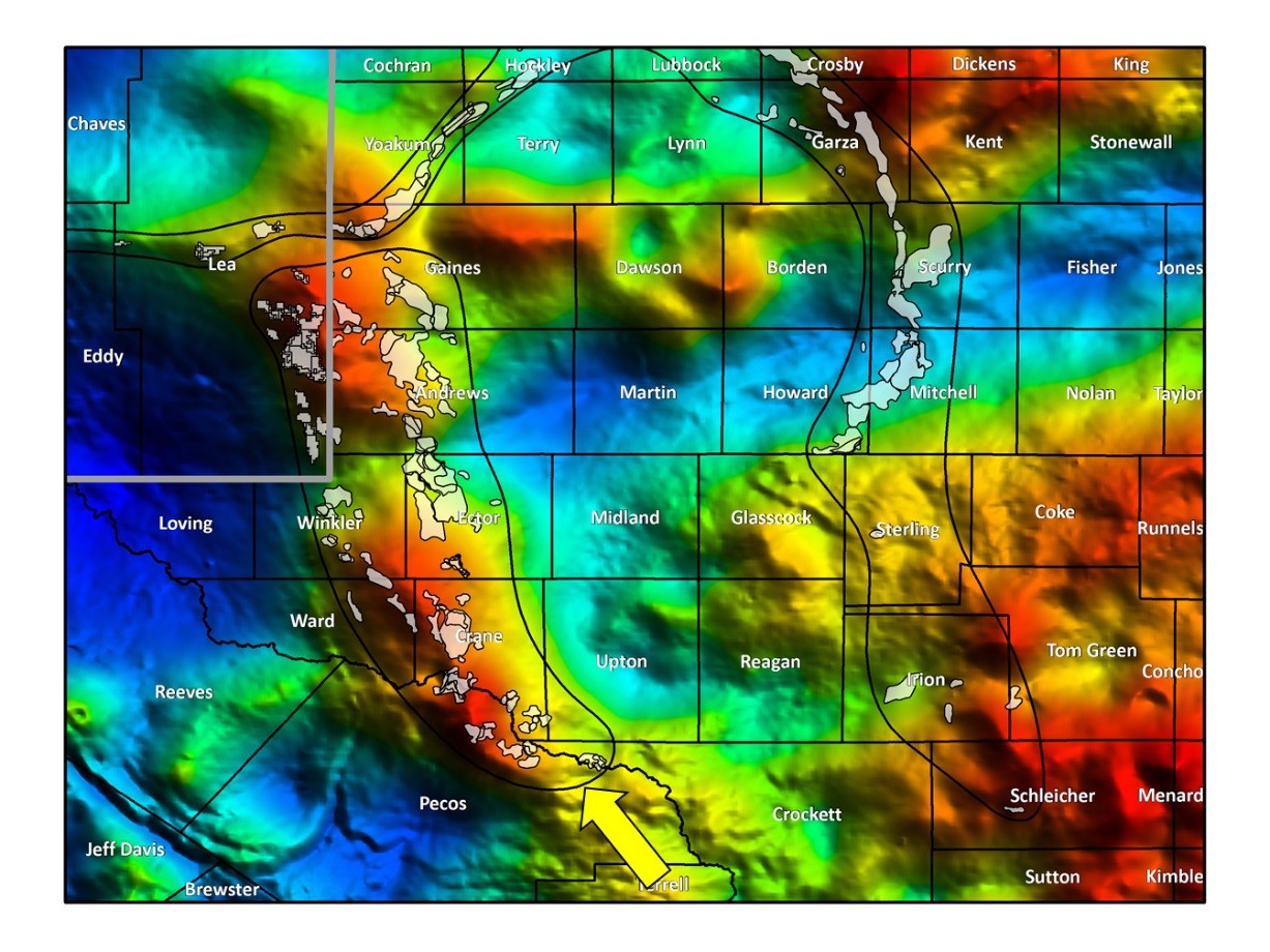
Figure 2. Bouguer gravity anomaly with locations of producing fields of the Leonard Restricted Carbonate Platform overlaid. Note the correlation with the NNW-SSE trending gravity anomalies indicated by the arrow.
Further north, there is apparently less direct correlation with the W–E to NE trend of the play from Lea county up through the counties of Yoakum and Terry. However, if we apply a 30 km high-pass filter (Figure 3) to the Bouguer gravity anomaly, we see clear correlation of the producing fields with a sharp, coherent, residual high that snakes along the same path when these are overlaid (Figure 4). The application of this filter helps to highlight the short-wavelength gravity response that is otherwise masked in the background field.
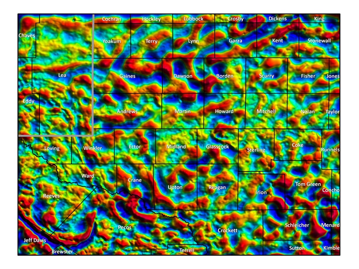
Figure 3. 30 km high-pass filter of the Bouguer gravity anomaly.
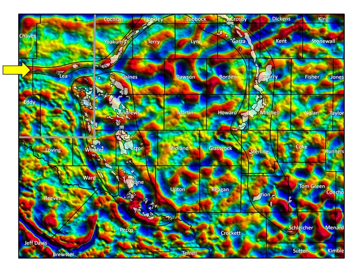
Figure 4. 30 km high-pass filter of the Bouguer gravity anomaly with locations of producing fields of the Leonard Restricted Carbonate Platform overlaid. Note the correlation with the snaking E-W to NE-SW trending short wavelength gravity anomalies indicated by the arrow.
The Artesia Sandstone Play
The striking correlations in this map are not limited to the Leonard Platform Restricted Carbonate Play. Towards the western side of the map, we observe a change of character in the 30 km high-pass Bouguer residual gravity anomaly. Figure 5 highlights a zone of sharper, generally shorter wavelength NNW–SSE features trending from Pecos and Ward counties to Lea county, before swinging round to a more E–W orientation into Eddy county. In this zone, there are known prominent producing fields associated with the multi-billion bbl Artesia Sandstone Play. When we overlay the location of the Artesia Fields (Figure 6), they are observed to be closely associated with this distinct zone of different character gravity anomalies.
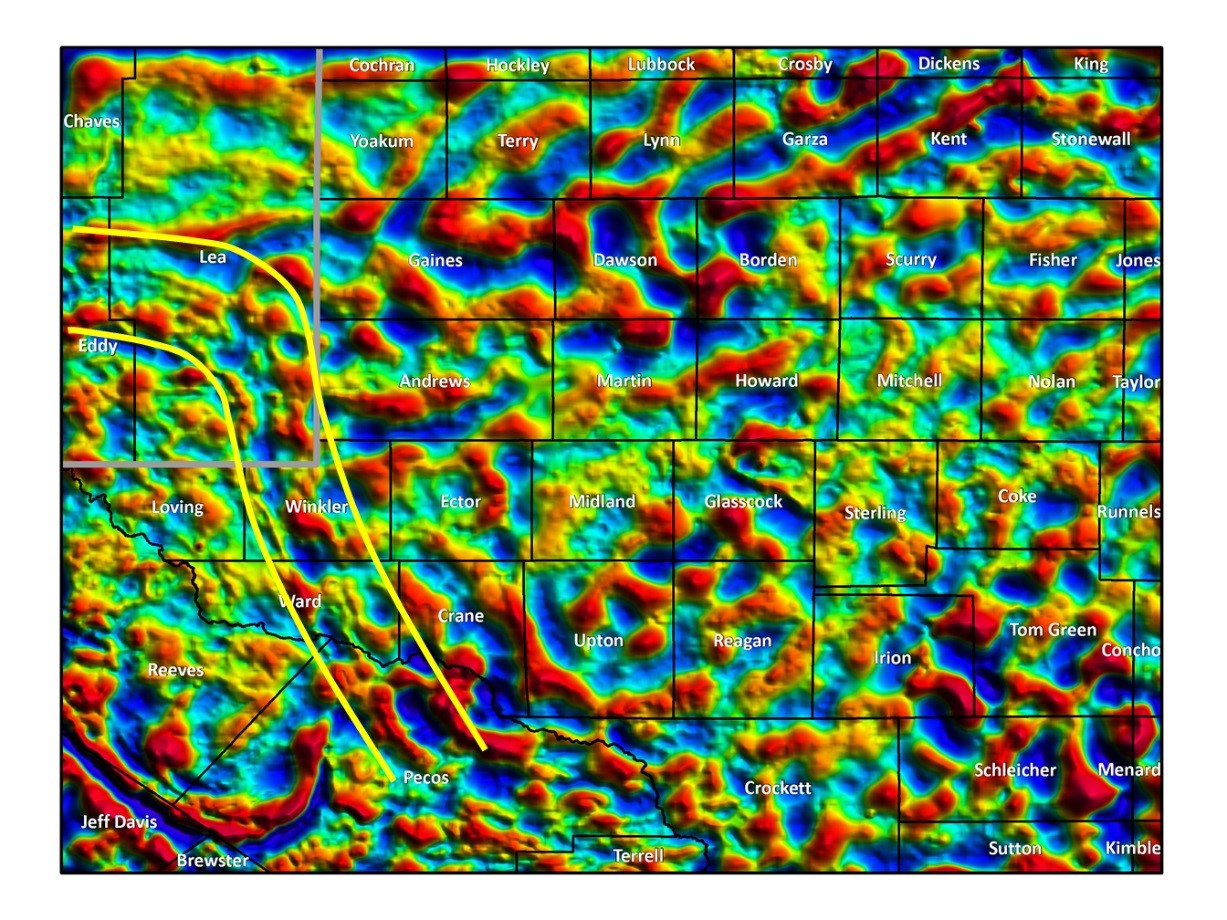
Figure 5. 30 km high-pass filter of the Bouguer gravity anomaly with a zone of sharper, shorter wavelength NNW–SSE features highlighted.
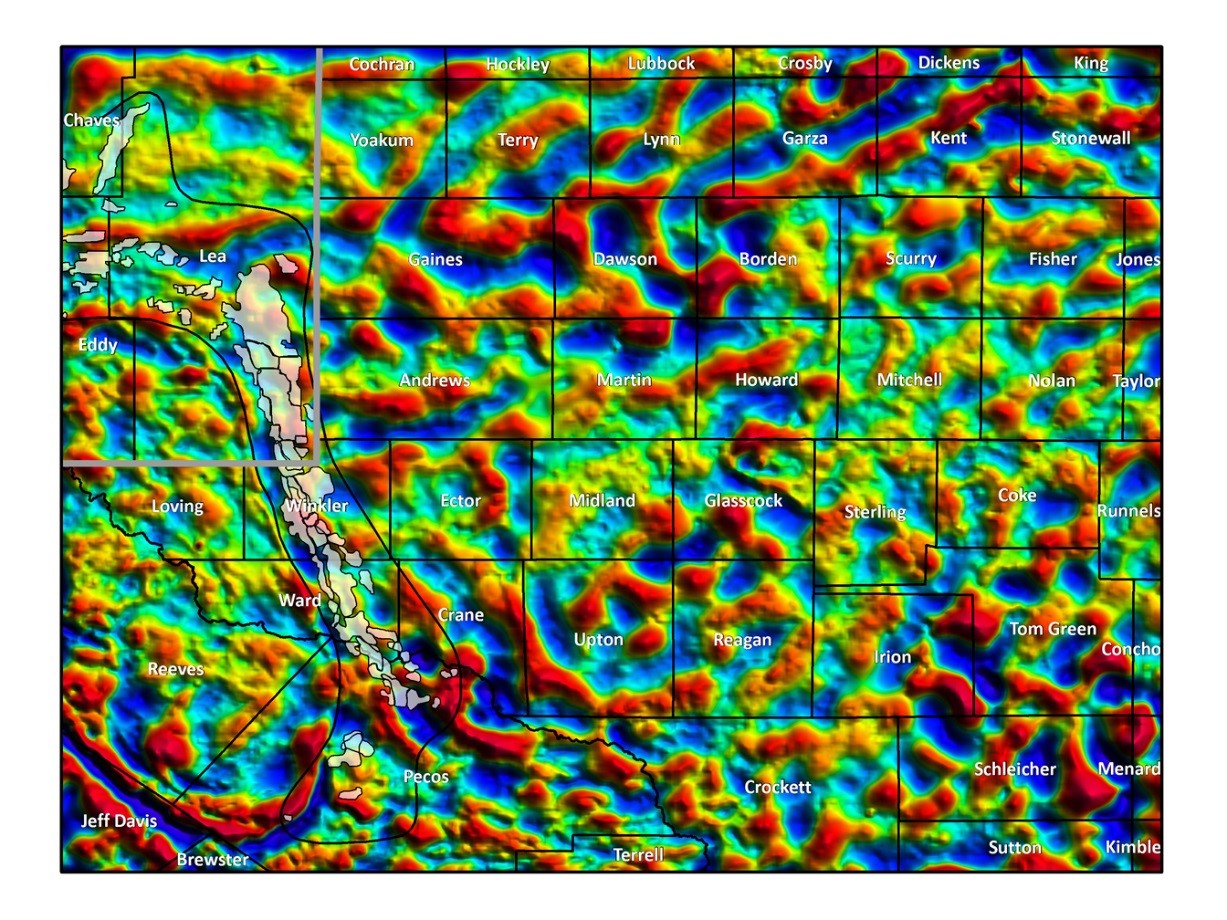
Figure 6. 30 km high-pass filter of the Bouguer gravity anomaly with the producing fields of the Artesia Sandstone Play overlaid, Note the correlation with the zone of NNW–SSE features highlighted in figure 5.
Conclusion
Gravity data shows an excellent correlation with known producing hydrocarbon fields in the Permian Basin. In this blog, we have highlighted two examples of this, but many other examples are observed in a variety of play types. This demonstrates the value of incorporating expertly reprocessed, high-resolution, ground gravity data as part of a balanced exploration programme. Direct correlations can be made and by extension, potential new opportunities can be identified in an extremely cost-effective manner.
To find out more about our unparalleled gravity data in the Permian Basin or how our integrated interpretation services can help you identify new prospects, please contact our specialist gravity and magnetics team at gravmag@getech.com.
Posted by Simon Campbell, Getech Head of Gravity and Magnetic Solutions


