Creating tectonic reconstructions requires diverse data from across geology and geophysics; methods and techniques to uncover the tectonic evolution of one area often don’t apply to another.
In this series of articles (don’t miss Part 1 and Part 2) we look at interesting tectonic problems from around the globe, the data required to solve them and why better understanding of the tectonic systems leads to better insights into the formation and preservation of petroleum systems and ultimately better exploration decisions.
In Part 3 the tectonic evolution of the Mozambique Coastal Plain is examined by looking at the crustal architecture of the region within the context of the break-up of Gondwana.
Part 3 – Crustal Architecture and Plate Tectonics in South Africa and Mozambique
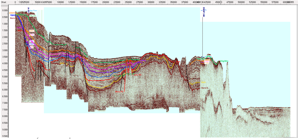
Off the East Coast of South Africa, the imaging of a deep water sub-basin outboard (Figure 1) of the previously discovered Durban Basin caused us to rethink the crustal architecture and tectonic evolution of the basin.
Given that the basin is likely to fill attenuated continental crust it is required that the continent-ocean boundary (limit of oceanic crust) is pushed eastwards by upwards of 140 km. Understanding the tectonic origin of this block of extended crust requires evaluation of the crustal structure of neighbouring basins and margins.
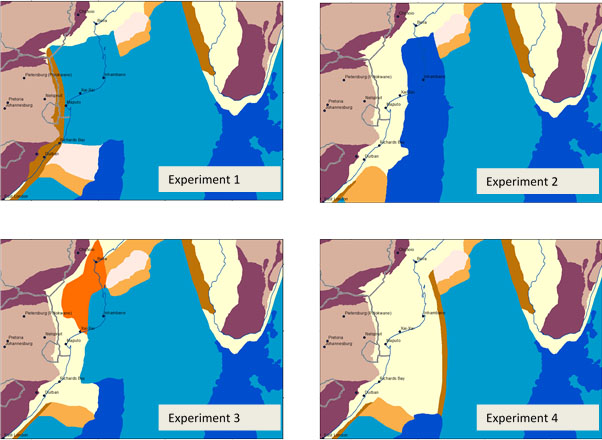
Four possible configurations of crust and tectonic evolution models could explain the presence of the unusual spur of continental crust offshore Durban (Figure 2). We have produced experimental tectonic models incorporating the various configurations to test the validity of each model given the ambiguity of constraining data. Whilst the variations are quite subtle, some have significant impact on regional tectonic reconstructions.
- Experiment 1 interprets the Durban Block as a displaced fragment, possibly the lateral equivalent of the Beira High in Mozambique. The Block is moved south by Jurassic seafloor spreading in the Mozambique Coastal Plain (related to Antarctica-Africa rifting) and is abandoned when the spreading ridge becomes extinct and Atlantic tectonics take over
- Experiment 2 interprets the Durban Block as being the southern edge of a band of attenuated crust stretching north into Mozambique. It forms in situ and is attenuated due to an early phase of Antarctica-Africa rifting in a broadly east-west direction. The remaining crust east of the block is highly intruded or thickened oceanic crust.
- Experiment 3 is a variation of Experiment 2, where the width of the Durban block is increased to reflect the deep-water basin imaged in Figure 1. In this case the block also forms in situ, perhaps with only the outermost part of the continental crust displaced from the north. The Mozambique Coastal Plain has undergone strong attenuation, perhaps progressing into transitional domain, with voluminous igneous additions to the crust.
- Experiment 4 is an extreme variant of the in-situ models, where a wide band of continental crust (up to 800 km) is present off the east coast of South Africa and in southern Mozambique. This model requires extensive attenuation of the margin in the east-west direction prior to the main Antarctica-Africa rift event in the Middle-Late Jurassic.
To assess the value of each crustal type we generated tectonic reconstructions for the Middle Jurassic to Cretaceous (i.e. the break-up of Gondwana); whilst passable models are possible for each configuration of crustal type in Durban and Mozambique, it is simplest that the Durban Basins formed in situ.
A further test would be to examine the provenance of sandstones in the Durban Basins to determine their origin either locally or from further to the north. Model 4, in which a wide belt of continental crust is present off East Africa, is least plausible due to the large overlap with the continental crust of Antarctic in a Jurassic reconstruction.
Seismic data collected in around the Mozambique Coastal Plain indicate large volumes of magma and seaward dipping reflectors, suggesting the Plain is underlain by some sort of juvenile igneous (or proto-oceanic) crust rather than true oceanic crust. While experiment 2 provided a model compatible with our global plate circuit, experiment 3, with an in-situ Durban Block may be a more accurate reflection of the crustal character.
As with other examples, constraining the tectonic evolution of an area of exploration potential allows for better evaluation of petroleum systems in the region. In this case the deep-water sub-basin offshore Durban is most likely to form in situ and therefore the petroleum systems are likely to be analogous to neighbouring sub-basins. To the north, the presence of igneous crust and surface volcanics may limit petroleum potential to cretaceous grabens in the southernmost Mozambique Coastal Plain.
Written by: Peter Webb, Catherine Hill and Jean Malan
Part 1: Provenance Analysis in Myanmar
Part 2: Multi-sat gravity data in the Gulf of Mexico

