Creating tectonic reconstructions requires diverse data from across geology and geophysics; methods and techniques to uncover the tectonic evolution of one area often don’t apply to another.
In this series of articles (follow the link for Part 1: Provenance Analysis in Myanmar) we look at interesting tectonic problems from around the globe, the data required to solve them and why better understanding of the tectonic systems leads to better insights into the formation and preservation of petroleum systems and ultimately better exploration decisions.
Here, in Part 2 we use cutting edge satellite gravity data to confirm the leading tectonic evolution model for the Gulf of Mexico.
Part 2 – Multi-sat gravity data in the Gulf of Mexico
In the Gulf of Mexico, the usual tools for defining plate motions in oceanic basins have traditionally not yielded good results. Magnetic anomalies are low amplitude due to the near-equatorial latitude of the Gulf; gravity anomalies have been obscured by thick sedimentation, salt and subsidence since the start of the Cretaceous.
Consequently, several models for the opening of the Gulf of Mexico have been proposed over 30 years. The most commonly proposed model uses palaeomagnetic data from the Yucatan Peninsula to suggest an approximately 40° anti-clockwise rotation of the peninsula away from North America to open the Gulf of Mexico.
Advances in satellite gravity technology have allowed Getech to develop a Multi-Satellite gravity data set using data from four satellites, leading to an increased density of satellite tracks and much improved data resolution and accuracy. This data represents a significant improvement in the Gulf of Mexico and allows for robust identification of tectonic structure in the Gulf (Figure 1).

Using the newly derived gravity data and a variety of derivatives and filters, we have identified a sequence of near-parallel, curvilinear features interpreted as fracture zones. Strong lineations corresponding with seaward dipping normal faults are interpreted as the limit of oceanic crust on the Yucatan margin of the Gulf of Mexico. On the northern margin, salt deposition masks the boundaries in the central region, but continuation of features mapped to the east and west indicates a boundary in keeping with the anti-clockwise rotation of the Yucatan Peninsula from the northern margin.
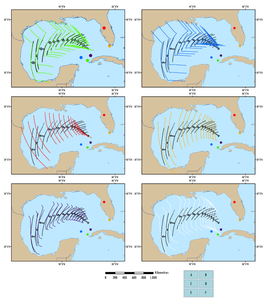
Sub-parallel, curvilinear features throughout the Gulf are interpreted as fracture zones that offset sections of the extinct spreading ridge. We tested existing models of tectonic evolution of the Gulf of Mexico by plotting the plate motion path of the Yucatan Peninsula with respect to the North American Plate.
Figure 2 shows a selection of Getech and publicly available tectonic models with the plate motion flowlines (colours) plotted over the mapped structure (black) and the location of the Euler pole of rotation as a dot. Getech’s preferred model is derived independently from that proposed by Pindell and colleagues, so confirms the counter-clockwise rotation hypothesis for the Gulf. Other models do not produce plate motion paths that closely match the newly mapped fracture zone structure.
With an established and robust tectonic model for the formation of the Gulf of Mexico we can be confident of rift geometries and timings. Petroleum systems and source to sink relationships for Jurassic rift basins can be analysed using our tectonic model; detailed palaeogeography maps can be constructed across neighbouring North, Central and South America to assess the potential environment for sediment source and sink areas during the Jurassic break-up of Pangaea.
Written by Peter Webb and David Sagi
If you missed Part 1, click on the link to recap: Provenance Analysis in Myanmar

