Valuable resource
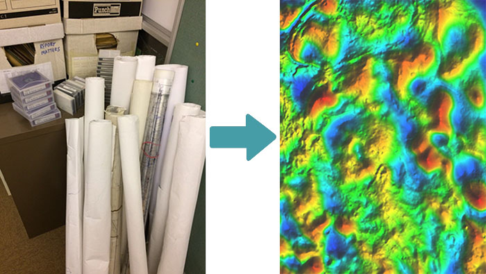
Many oil companies, mining companies and government agencies have extremely valuable data resources languishing in store rooms and digital archives. Gravity and magnetic data have been acquired and been used in hydrocarbon and mineral exploration since the early part of the 20th century. In spite of the advances in data acquisition technology most of these data are still valid exploration resources. This means that a huge volume of legacy data exists, data which could be being used to reduce exploration risk.
Specialist skills
For over 30 years, and on every continent on earth, Getech has worked with custodians of these data sets to carefully recover, reprocess and merge these data to significantly enhance their value and usability in the modern exploration industry. Typically the work may involve:
– Digitising of archive maps: this might include meticulous analysis to uncover original processing parameters, map projections and the marrying together of real data locations with mapped outputs. Getting back as close to the originally acquired data as possible is key.
– Unravelling of digital data: the deciphering of long-abandoned binary and ascii data formats is not a trivial task and having encountered data from many thousands of surveys covering a vast range of vintages and contractors, the Getech gravity and magnetics specialists are well placed to work this out.
– Reduction to consistent parameters: reprocessing to common parameters is particularly important where data sets of differing vintages and of different provenance are to be merged. This needs to be done in a technically robust manner so as not to compromise the value and integrity of the original data. Often this will involve the unpicking of the original processing workflow to ensure that all corrections have been calculated and applied correctly.
– Micro-levelling: data measured along lines, particularly on a moving platform (e.g. ship or aircraft), often have residual line related artefacts. We observe line noise in many data sets, including within relatively modern surveys, and these significantly diminish their usefulness for interpretation. We have developed a proprietary technique to address this critical part of the process which removes the noise whilst retaining the high frequency, detailed data along line.
– Merging: having ensured that data are processed to common parameters, additional care needs to be taken to ensure that any reference fields or datum shifts are applied in a consistent manner. Data sets should be merged in a way that reflects the value, accuracy and resolution of the constituent surveys without any deleterious effects on the individual input surveys. The aim is to produce consistent gravity or magnetic data sets that can be easily interpreted, both qualitatively and quantitatively across survey boundaries.
“New” data sets
Data that have been recovered, reprocessed and carefully merged can give the explorationist what is effectively a brand new data set. Free from line noise, artefacts and merging busts, they are much more interpretable, reliable and significantly more valuable: an essential partner to other data sets such as seismic and wells.
Individual survey case: The example below shows an aeromagnetic survey where only a paper contour map was available. By digitising along flight lines at contour intercepts we can get back as close as possible to the original magnetic anomaly data and then process these line data to a digital grid (part of which is shown overlaid). With the data in clean, digital format, advanced processing techniques can be applied to pull maximum information from a data set that might otherwise has been left to one side.
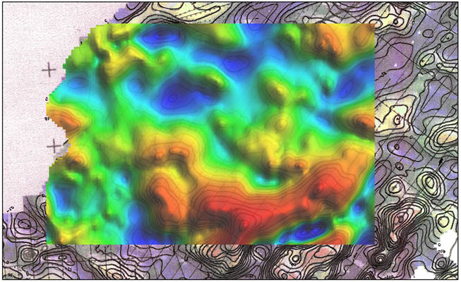
breathes new life into a data set that might otherwise have been left to one side.
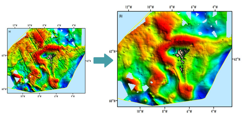
Multiple survey case: Reprocessing individual legacy surveys to diminish line noise and other artefacts is one part of the story. Combining these with other neighbouring and intersecting surveys is another challenge. In the example below when data from multiple gravity surveys of varying vintages from around the Faroe Islands are simply pooled together, inter-survey busts can clearly be observed even though each survey has individually been well-processed (a). Careful levelling of all of the merged survey lines can solve this issue leading to a data set ready for robust regional analysis (b).
Summary
Data that may have been used many years ago, acquired alongside other data and put to one side, or simply forgotten about may still retain significant value to potentially enhance your exploration campaign. Careful and rigorous expert recovery and reprocessing can reinvigorate these data sets, save money on new acquisition and help de-risk your exploration efforts.
Written by Simon Campbell and Matthew Stewart


