


Last year we released Globe 2021, the latest edition of our market-leading geoscience knowledge base. Each annual release adds innovative content and enhanced usability, and Globe 2021 is no exception. In this blog I outline 5 of my favourite features in Globe 2021…
1. Tectonic Events Catalogue
This new feature Getech’s extensive knowledge accumulated while creating our Global Plate Model, Global Structural Framework and Global Crustal Architecture – previously only available in this format via individual Regional Reports.
The Tectonics Event Catalogue in Globe 2021 describes rift events at over a hundred localities, in the Atlantic, South China Sea and Indochina regions. Attribution for each event includes critical information such as the tectonic association, timing and type, as well as a detailed report (Figure 1) containing further commentary on the crustal architecture, structural configuration, timing, causes, kinematics and consequences of the event – all illustrated with supporting maps and figures, including relevant 2D Gravity and Magnetic Profiles.
The events are presented in present day and palaeo location on Globe’s 1:5 M scale palaeogeographic reconstructions, providing you with a detailed perspective of the mechanisms driving tectonics, controls on the depositional systems, hinterland physiography, the developing conjugate relationships, thermal character and subsidence for your stratigraphic level of interest.
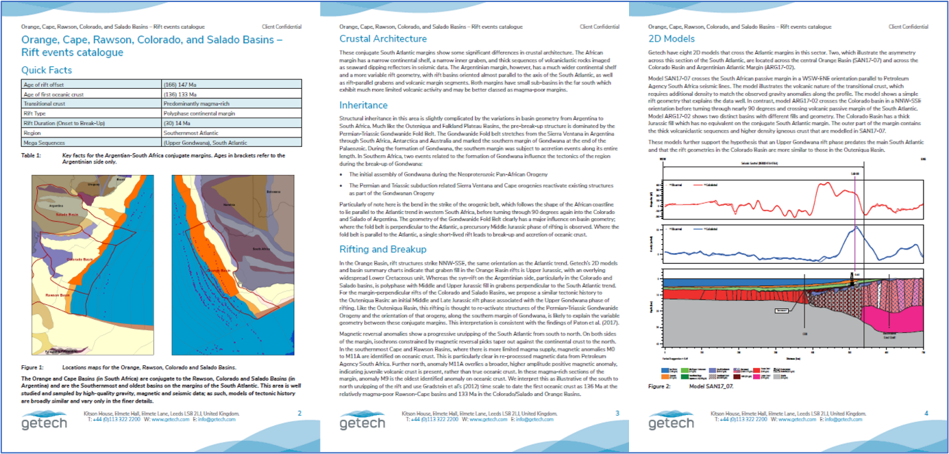
Figure 1- Example Tectonic Events Catalogue report.
2. Enhanced Palaeogeographic Confidence
Globe 2021’s new Palaeogeographic Confidence Grids consist of fully attributed confidence layers for each cronostratigraphic level from Permian to Pleistocene (58 timeslices). The layers are based on input factors such as the presence of mapped structures (including average mapping confidence and age of movement confidence), density and quality of data points (amount, age confidence and location precision) and whether there are detailed Getech reports for the area present.
Confidence is represented as a sum of the inputs, with a maximum score of seven achieved by meeting all criteria, representing the highest data confidence (Figure 2).
This user-friendly scheme provides you with much greater confidence when integrating Globe’s data with your own workflows, and obviously also allows you to compare different Globe regions or time intervals subjectively.

Figure 2 – Example data confidence layer.
3. Thermal Mapping
Globe 2021 sees the release of the fourth year’s results of our Thermal Mapping project. This year-on-year research continues to improve our understanding of Present Day temperature and heat flow at depth, providing essential information for investigating source rock maturation, the potential effects of temperature on reservoir quality, conditions for mineral deposits, and Geothermal Energy potential. The Thermal Mapping research made use of Getech’s extensive terrestrial and satellite derived magnetic data, as well as various public domain heat flow databases that have been combined into a single harmonized, quality-controlled database.The key elements and deliverables of this fourth year of research are:
- Upgrade of Globe’s global heat flow layers, including further QC of the original public domain data sources. The heat flow database contains near-surface heat flow measurements, basement heat production estimates and thermal conductivity data. This data review has been used to generate an updated global grid of surface heat flow with improved input data quality.
- An updated global Curie Temperature Depth (CTD) grid derived by integrating CTD estimated from our revised surface heat flow grid with the CTD inferred from magnetic approaches.
- Updated grids of predicted temperature at various depths below surface, derived from the updated integrated CTD grid and a physical model of the crust (Figure 3).
- Application of machine learning techniques:
A new global compilation of onshore surface heat flow estimates, predicted from machine learning techniques.
Temperature-depth grids from the machine learning-derived surface heat flow estimates and a physical model of the crust.

Figure 3 – Example temperature at 4 km depth map.
4. Cross Section Tool
We have always sought to provide new and innovative functionality within Globe to help you access, manipulate and visualise Globe’s rich databases.
In recent releases these tools have typically enabled you to query numerous data layers across multiple time stages at a particular point, e.g. to enable you to investigate how different climatic variables have changed through time.
The Cross Section Tool, new in Globe 2021, generates a 2D section along a user defined profile, for example through a sedimentary basin, or across a whole continental margin.
The output cross section displays topography and bathymetry along with Globe’s crustal types, depth-to-basement, depth-to-Moho and Curie Temperature Depth (CTD), providing you with a quick and detailed depiction of the basin/margin architecture and critical depth information for your area of interest.
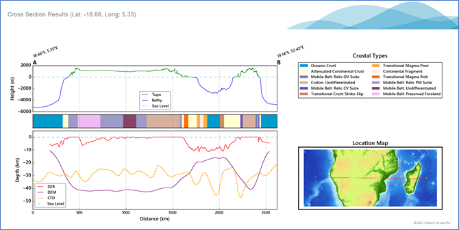
Figure 4 – Example output of the Cross Section Tool output
5. 2D Gravity and Magnetic Profiles
2D Gravity and Magnetic Profiles provide an excellent understanding of the crustal configuration of a region or basin, valuable information in determining thermal and subsidence history, as well as the broader structural configuration and tectonic controls. For Globe 2021, we added 30 new profiles (largely focused on the SE Asia region) to Globe’s already extensive coverage across the world’s continental margins.
Globe’s more than 140 profiles use data from Getech’s proprietary Gravity and Magnetic database, supported with public domain seismic and well data, and are selected to answer important questions regarding the crustal architecture and basin geometry for key areas of interest.
Within Globe, mapping of crustal types and interpolation between profiles allow the detailed mapping of the Global Crustal Types layer, as well as providing constraints for the Global Depth-to-Basement module, both of which are updated in response to the outcomes of these new models. These models also provide important constraints and context for the detailed tectonic descriptions within the new Tectonic Events Catalogue.
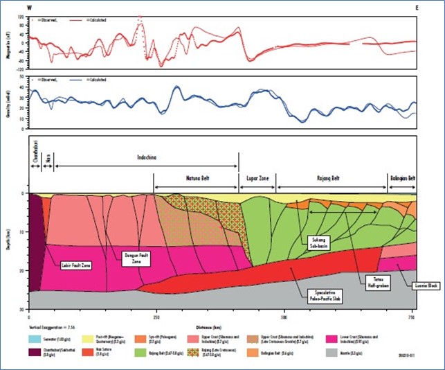
Figure 5 – Example 2D profile.
Summary
Globe is used widely for hydrocarbon exploration and is increasingly demonstrates value in the Energy Transition, including geothermal energy development, mineral exploration, and carbon capture and storage. Globe is available in both ArcMap and ArcGIS Pro versions, as well as an easy-to-use web-based version, Globe Online, designed to provide simple and quick access, particularly for those on the move.
To find out more about how Globe can help in your resource location workflows – including petroleum, strategic minerals, geothermal heat and storage reservoirs – please contact us at info@getech.com.
Posted by Dr Andy Quallington, Head of GeoInformation Products


