


Getech, providers of natural resources exploration data and expertise, is pleased to unveil its unparalleled, industry-leading gravity database for the Permian Basin.
These data constitute a vital component of any exploration campaign and are an essential, cost effective partner to seismic and well data.
Gravity data are routinely used in the hydrocarbons exploration industry to map subsurface fault patterns, identify local positive structures and depo-centres, map sediment thicknesses and delineate the locations and extents of anomalous bodies which may, for example, have a fundamental effect on the depositional environment or local thermal regime.
Moreover, these data compliment other types of exploration data such as seismic and wells helping the explorationist to “fill in the gaps” and narrow down interpretation uncertainties, hence de-risking the work program.
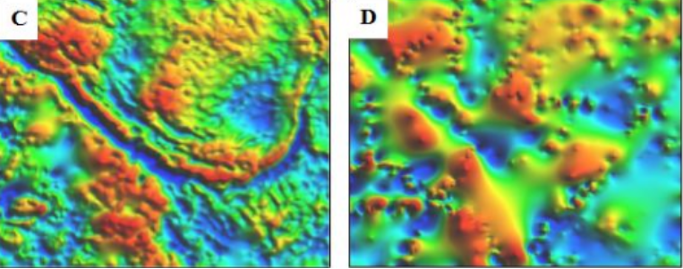
The Getech database benefits from an unparalleled resolution, significantly higher than data available from the public domain as illustrated in the images below.
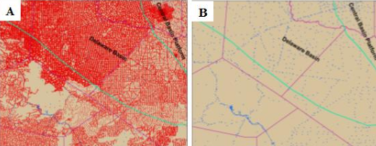
Example area from the Permian basin showing (A) Getech’s comprehensive gravity data coverage in comparison to (B) the public domain. The additional level of detail this enables is demonstrated in the first vertical derivative of the gravity from (C) the Getech’s proprietary compilation and (D) the public domain.
Getech’s Permian Basin data package, which is available for immediate delivery, includes a number of key data enhancements and derivatives designed to further highlight subsurface features of interest.
Contact Getech to learn more.


